

© Jordan Leone 2015

Seismic and Resistivity Interpreted Regolith Thickness
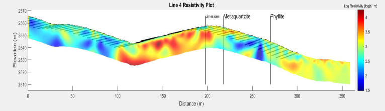
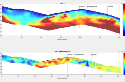
One of my major projects has been looking at seismic refraction and electrical resistivity data to interpret total regolith thickness and factors that govern its thickness; the blue in both images suggest areas that may be more heavily weathered.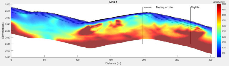
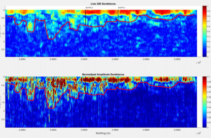
Ground Penetrating Radar Interpreted Soil Thickness
My other major project has been to interpret soil thickness from ground penetrating radar data. By looking at the coherency of the data through semblance analysis and instantaneous amplitude, I hope to be able to generate soil maps which will allow soil scientists to generate large scale maps of soil.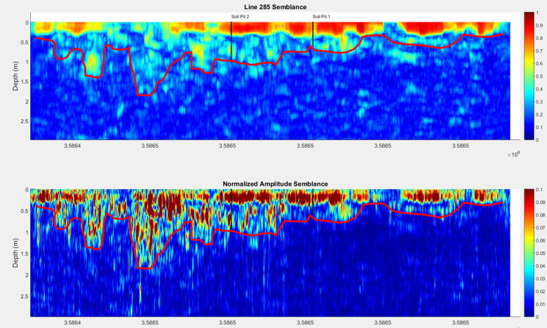
Research
My research for WyCEHG is focused in using near-surface geophysical techniques (i.e. seismic refraction, electrical resistivity, ground penetrating radar, and electromagnetic induction) to learn more about the factors controlling regolith thickness. Regolith is the near subsurface material which consists of soil and saprolite (very weathered rocky material). Regolith can act as a resevoir for water and contains many nutrients for plants and animals and thus is critical for life. My goal is to better understand the factors that govern the availability of regolith and the life sustaining resources that it provides. Below I discuss two of my major focuses.
Jordan Leone


© Jordan Leone 2015
Research
My research for WyCEHG is focused in using near-surface geophysical techniques (i.e. seismic refraction, electrical resistivity, ground penetrating radar, and electromagnetic induction) to learn more about the factors controlling regolith thickness. Regolith is the near subsurface material which consists of soil and saprolite (very weathered rocky material). Regolith can act as a resevoir for water and contains many nutrients for plants and animals and thus is critical for life. My goal is to better understand the factors that govern the availability of regolith and the life sustaining resources that it provides. Below I discuss two of my major focuses.
Jordan Leone

Seismic and Resistivity Interpreted Regolith
Thickness
One of my major projects has been looking at seismic refraction and electrical resistivity data to interpret total regolith thickness and factors that govern its thickness; the blue in both images suggest areas that may be more heavily weathered.
Ground Penetrating Radar Interpreted
Soil Thickness
My other major project has been to interpret soil thickness from ground penetrating radar data. By looking at the coherency of the data through semblance analysis and instantaneous amplitude, I hope to be able to generate soil maps which will allow soil scientists to generate large scale maps of soil.